Unified Messaging and Mapping
Index
When there’s an incident – a fire, derailing or traffic accident – every minute counts. It’s vital that you can locate and communicate with your team from the get-go. And for this you can rely on our Unified Messaging and Mapping solution.
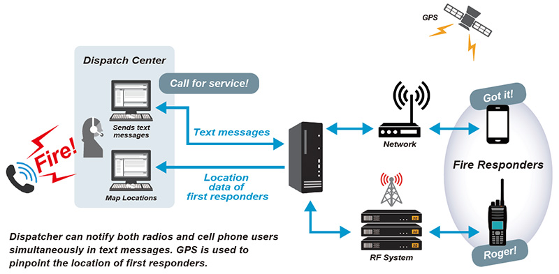
From the 1960s two-tone pagers have been used to alert volunteer firefighters of an incident, but today everyone carries a device vastly more sophisticated than a pager: the smartphone, equipped with GPS for accurate geolocation. Our cost-effective solution combines radios with phones and other communications assets to create a unified messaging and mapping system.
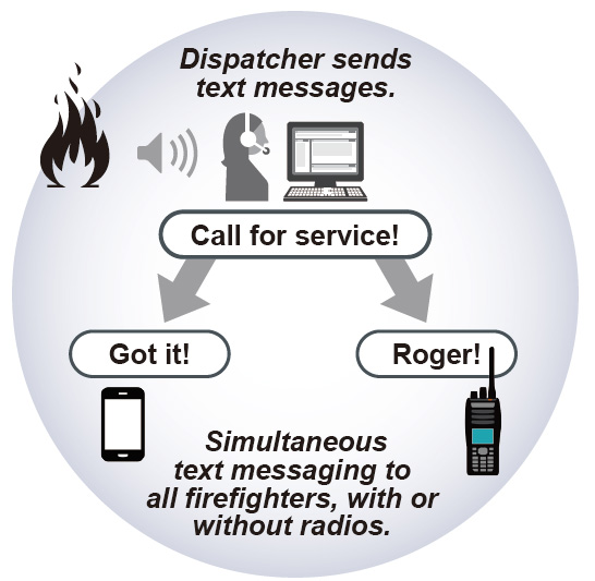
 By simply sending an email to the server, you can be sure your instructions will be automatically relayed to all of the radios and phones carried by your team. Also by using GPS data, you can instantly see where your first responders are,
and then issue instructions by voice or text. Their locations are logged to create a record that can be reviewed later to aid in improving response strategies or to support an accident investigation.
This solution delivers rapid and sustainable improvements in safety and efficiency while reducing overheads – plus the ability to audit your field staff and assets.
Compatibility
| NEXEDGE System | Portable Radio |
|---|---|
| Direct, Conventional Repeater,Type-C Trunking | NXDN Digital Radio |
Features & Benefits
For a complete solution, use of the Elert cell phone application
and Datagate messaging server offers several powerful
capabilities:
- Notify by phone or radio all or selected volunteers of an incident
- Leverage existing devices such as cell phones to reduce costs and add a level of redundancy
- Reach participants who do not have radios, extending the notification area to include all cell phone coverage
- Defeat out-of-range paging issues
- Deploy the closest responders
- Quickly receive acknowledgment from each firefighter with a phone: Not Attending, OK to Station, or OK Direct (or preset radio message)
- Eliminate the lost time and potential confusion of verbal-only instructions by using messages
- Get estimated time of arrival using phone app
- Identify the location of GPS-equipped radios and phones carried by volunteers
- Establish geo-fenced perimeters and receive automatic notification when personnel enter or leave the incident area
Additionally, the tracking, reporting and recording of each person’s GPS data and status provides continuous confidence in the location of staff and assets. This information also enables rapid and sustainable improvements in safety and efficiency, plus the ability to audit your field staff and assets.